


Next
Total Found: 557
Redland Bay Aerial Photography
From our base in the Gold Coast, at Skyepics we've spent decades capturing Australia's eastern seaboard from the air, culminating in an online library of over 27,000 images showcasing. We're passionate about creating premium quality images showcasing the natural beauty of Australia's east coast. Our library of images contains shots from Sydney in the south all the way up to Cairns in the far north, all captured with the latest Canon photography equipment.
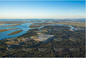
Stunning aerial photography showcasing Redland Bay's natural beauty
Located 35km southeast of Brisbane and bordered by Mount Cotton to the north west, Victoria Point to the north, Carbrook to the south west, Southern Moreton Bay Islands to the east, and Alberton and Woongoolba to the south, Redland Bay is an idyllic waterside suburb within stone's throw of Stradbroke Island.
The name Redland Bay derives from the red-toned soil of the bay which is caused by the large amounts of iron oxides in the area deposited by lava flows from an ancient volcano. This fertile green land washed by the warm waters of the bay makes a spectacular scene for aerial photography, with truly magnificent shots showcasing the natural beauty of the area.
Our library of Redland Bay aerial photography shows off lush greenery surrounding quaint residential streets and pockets of farmland, but the real star of the show is the tranquil blue bay which features in many shots.
Browse our library of Redland Bay aerial photography or order custom images today
Choose from our stunning collection of Redland Bay aerial photography, or for bespoke images get in touch for custom aerial photography.
Accessing your Redland Bay aerial photography is simple. Once you've made your payment simply choose the images you want for instant download. Need multiple images? Check out our fantastic aerial photography packages for savings of up to 78% on all our aerial photography.
